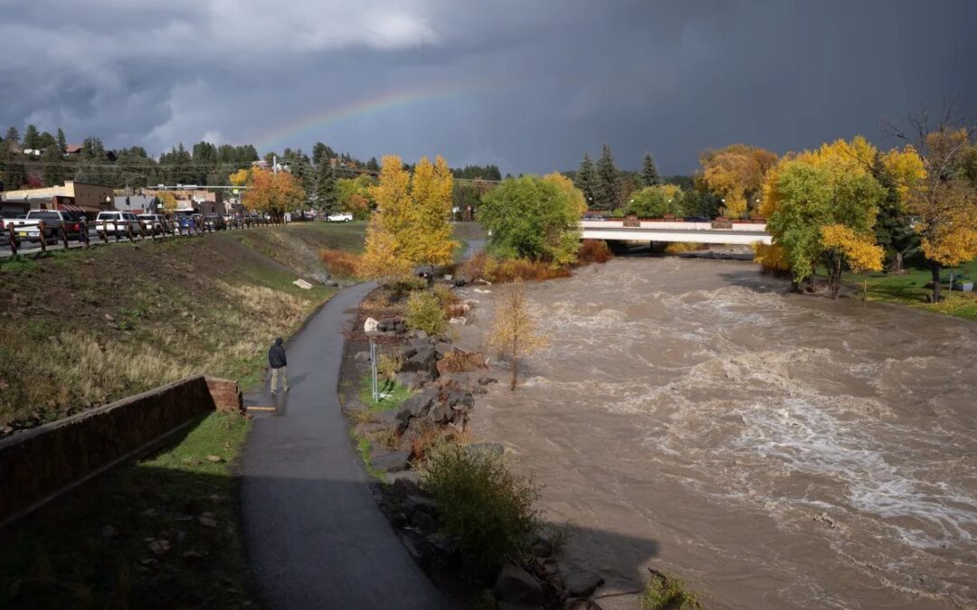
Tropical storms that drenched southwestern Colorado caused rivers to swell to levels unseen since the 1970s and doubled the amount of water in one small reservoir in La Plata County.
Two storms in the Pacific, Hurricane Priscilla and tropical storm Raymond, dropped 512% of the normal amount of precipitation for southwestern Colorado for October.
Communities were just starting to recover Tuesday from flooding, evacuations and damage to roads and bridges with more storms on the way. The influx of moisture was also a boon for shrunken reservoir storage after a dry summer.
“We’re not out of the woods quite yet,” said Kate Abbott, a National Weather Service meteorologist.

Near Pagosa Springs, flows in the San Juan River peaked around 4 a.m. Tuesday at 12.6 feet deep, its highest level since 1970, before dropping at about 9 a.m., the Archuleta County Sheriff’s Office said. The river was about 12.25 feet deep as of 11 a.m. When river levels drop below 9.48 feet and county crews can finish assessing damage to make sure the area is safe, mandatory evacuations in the county will be lifted.
Before the storms arrived Friday, the water level hovered just under 4 feet. The San Juan River starts to flood at 10.5 feet.
About 40 miles west in La Plata County, about 90 homes north of Vallecito Reservoir were damaged by the floodwaters including two homes that were deemed a total loss after Vallecito and Grimes creeks washed out underneath them, county officials said. More than 390 homes have been evacuated since Saturday.
Hundreds of residents evacuated from flooded neighborhoods in southwestern Colorado could be allowed to return home by Tuesday afternoon as the San Juan River and other overflowing streams start to recede.
No injuries have been reported as of Tuesday morning.
Most of southwestern Colorado saw about 1.5 to 3 inches of rain, but mountainous areas have received closer to 4 inches since early Monday morning, according to the National Weather Service in Grand Junction.
As stream flows start to recede, the weather service is keeping its eye on possible thunderstorms that could hit the region Wednesday evening.
These thunderstorms could bring a fast influx of water and increase the risk of mudslides and flooding in urban areas. So far, no mudslides have been reported in scars from this year’s wildfires, Abbott said.

More flooding in Archuleta County
The storm dropped up to 4 inches into the San Juan River watershed upstream of Pagosa Springs in Archuleta County. The town of Pagosa Springs received closer to 1.5 to 2 inches of rain.
“A lot of that water fed into the San Juan River and resulted in another round of flooding,” Abbott said.
Floodwater and debris in Pagosa Springs caused sewer lines to fail below the First Street Bridge on Highway 160 on Tuesday morning and temporarily shut down the road, according to the police department.
As of 4:48 a.m., emergency crews were on scene assessing the damage.
Schools in Archuleta County were also closed Tuesday due to the high water and impact on county infrastructure, according to the sheriff’s office.

Monday night showers at Vallecito
Hundreds of residents left their homes north of Vallecito Reservoir over the weekend as rain caused creek and river levels to surge, damaging bridges and limiting evacuation routes. The reservoir is tucked away in a remote area of La Plata County, about 20 miles northeast of Durango.
The sun was shining Tuesday, but Vallecito and Grimes creeks were still rising, Sarah Jacobson, a La Plata County spokesperson said. Emergency crews discovered more breaches while surveying the area and more rain is on the way.
“We all want to get people back in their homes and they want to get home and assess the damage of their property, but it’s just too uncertain right now,” Jacobson said. “We haven’t had an opportunity to do any damage assessment to make sure that all the private roads are passable and safe. Do the homes have water and sewer access? Are the propane tanks safe or are they leaking gas? Are there trees that are in danger of falling on somebody? It’s a lot.”
An incoming storm is expected to bring between 0.2 to 0.8 inches of rain starting Tuesday afternoon through Wednesday, she said. The county assessor’s office plans to do damage assessments Thursday and Friday.
“Everything’s waterlogged right now, and there’s no room for additional capturing of the water. Everything is full,” she said.
Vallecito Creek crested at about 4.35 feet at around 4 a.m. Tuesday, Abbott said. Over the weekend, its peak was about 6 feet before it receded during a lull in the rain showers.
“It’s going back up, so that might not be the final crest from this push of rainfall,” she said.
The water from the storms rushed into Vallecito Reservoir, which was built in the 1940s mostly to provide flood control and irrigation water.
Mike Canterbury, a dam tender for the Pine River Irrigation District, was driving on the east side of Vallecito Reservoir on Tuesday morning to check for trees or other debris from the floods.
Before the storms, the reservoir held 28,000 acre-feet of water, about 22% of its 125,000-acre-foot capacity. One acre-foot roughly equals the water used by two to three households each year.
“It was starting to look pretty pitiful,” he said.
As of Tuesday morning, the reservoir held almost 56,000 acre-feet of water and had risen by 15 feet or more, Canterbury said.
The reservoir managers were worried about carrying enough water into the spring in case the region had a mediocre winter, he said. Canterbury described the water as a “godsend,” giving them enough water to produce hydropower and have a more stable irrigation supply heading into next summer.
“At this point, we could store plenty more water,” Canterbury said.
 Print
Print